

Drone City
By Ekaxi Hernandez
Date
June 11, 2019


Cities are compelled to respond to technology’s growing presence in our lives, while companies compete to save the day. Now, in the preparation for the imminent arrival of drone services, Amazon, AT&T, and UPS are racing for their share of the sky.
The Case for Drone Delivery Services
More delivery trucks on the road will only increase traffic congestion and add pressure to already exhausted curb space. By shifting the last-mile of the delivery system to the skies, delivery services will be able to keep up with demand without adding congestion or increasing GHG emissions.
A comprehensive study by the RAND Corporation analyzed the city scale impacts of a potential drone delivery system. They concluded that shorter drone delivery routes yield lower energy consumption, lower aerial congestion, and lower noise pollution. Thus, drone delivery services are best suited for urban areas with higher customer density and shorter flight distances. In high-urban settings, drones will need three things:
- A network of distribution centers or ‘drone hubs’
- Clear rules of where drones will fly or ‘aerial zoning’
- Places to land and deliver goods or ‘building pads’
Drone Hub Network
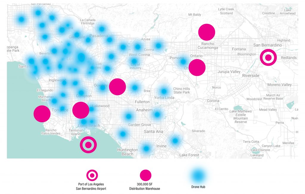
Figure 1: A network of ‘drone hubs’ would be connected to the regional distribution system’s distribution warehouses and major ports of entry. The denser the area, the more drone hubs will be needed to serve the existing customer base. Image source: IBI Group. Click here to view larger image.
Existing distribution centers from shipping services like FedEx and UPS could provide the initial infrastructure for drone hub networks. However, they are not compatible with drones in their current forms. Designing drone hubs from the ground up offers a unique opportunity to fully automate the local delivery system. By integrating automated storage and retrieval systems, drone hubs could provide an autonomous system that receives, sorts and delivers packages.
Aerial Zoning
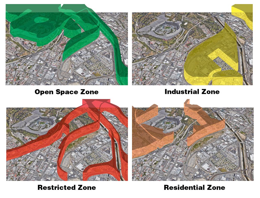
Figure 2: Land use zoning maps are best candidates for an aerial zoning map framework that regulates drone airspace use. Source: IBI Group, based on Google Earth. Click here to view larger image.
There is significant concern over the potential impact that drones will have on airspace. Existing regulations are very strict on drone activity and are thus a major barrier to adopting drone technology. A blog post by Mitchell Sipus proposes utilizing existing land use maps as a starting point to begin thinking about aerial zoning. This approach helps to understand and identify areas that are compatible with drone traffic based on the urban landscape.
Figure 2 shows an area over Los Angeles that includes four zones typically identified in zoning maps. These zones, alongside other city zones, are a good framework for estimating the typologies of buildings and human activities that conceivably happen on the ground.
For example, airspace above freeways or railroads, as well as airspace near schools and airports should be restricted to minimize any risks to infrastructure and people. Zones can also apply maximum flight speeds and minimum heights and grant exceptions for certain drone use in cases such as medical or emergency response drones.
Building Design
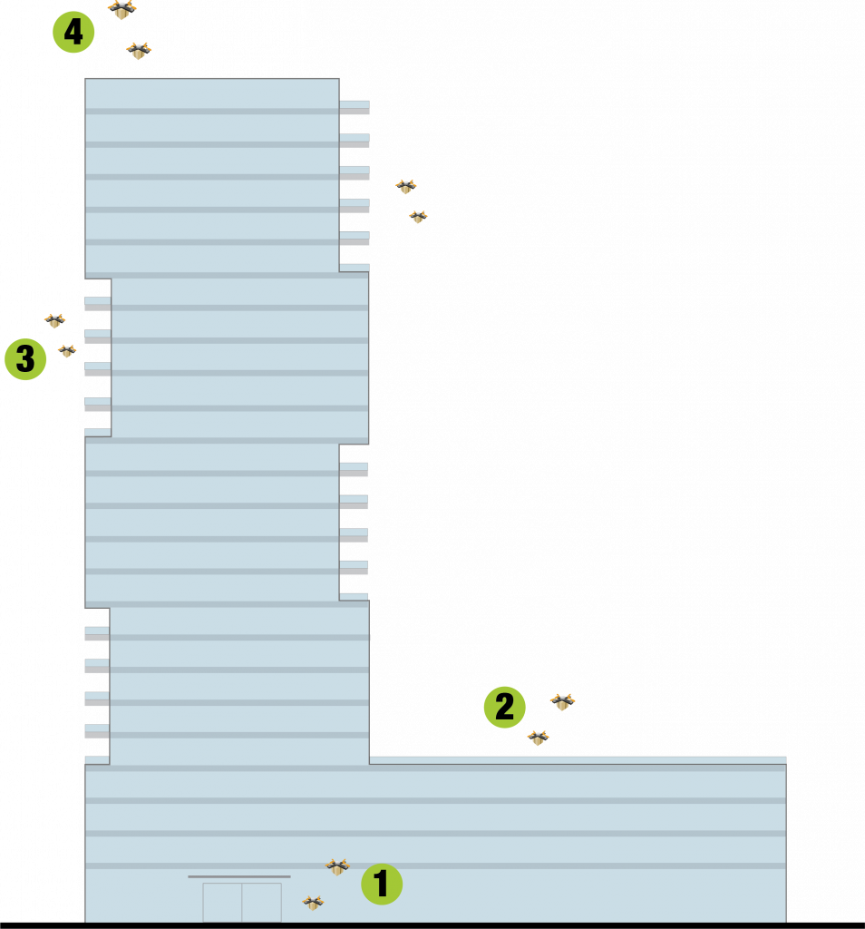
Figure 3: Residential and mixed-use high-rise building offer four locations for goods delivery via drones, which would de-congest ground floor loading and storage areas. Image source: IBI Group.
High-rise buildings dedicate significant ground floor space to service-related uses such as loading docks and mailrooms to accommodate deliveries. Drones offer the opportunity to move this service off the ground, thereby freeing up space for more productive and profitable uses. Moving past traditional ground floor delivery service, there are four possible alternatives for landing pads/delivery receipt areas for multi-story buildings:
Operable Windows: Office buildings could include a special operable window that allows drones to access a dedicated delivery area on each floor or office suite. This option gives office tenants the ability to send and receive drone deliveries at their convenience without going through communal services or areas.
Amenity Decks: The majority of new high-rise buildings include parking podiums with an amenity deck at the top. Designers could allocate space for a landing pad in the space with an adjacent mailroom to contain both services in one space.
Balconies: Current drone landing pads are 5ft in diameter and would easily fit in a typical balcony design. However, balconies would need some sort of identifier that guides the drone to the correct balcony, however.
Rooftop Landings: Building rooftops could be retrofitted to serve as drone landing areas. This option provides the ability for existing buildings to take part in drone delivery systems.
Drone City of the Future
Drone technology has finally matured to a point where drone delivery is a very real possibility. Now, it is not a question of if, but when. There are several initiatives underway that will adopt drones and further evolve the way people experience the city. Earlier this year, Uber released a white paper on their UberAir initiative that investigates how a drone rideshare could work, the Norman Foster Foundation is exploring the possibility of helping third world countries leapfrog waves of infrastructure with drones and droneports, Delft University of Technology is researching ways to expedite emergency response with Ambulance Drones, and AT&T and Verizon are using drones to restore cell service in areas that experienced natural disasters. The real challenge lies in the preparation for the new era of Drone Cities.
This article is based on the findings of “Drone City“, an internal Pocket R&D report by Ekaxi Hernandez. Pocket R&D is IBI’s tactical micro-research initiative that taps into the knowledge of our talent pool to inform how we can define the cities of tomorrow.
ABOUT EKAXI HERE
